File:Hayden-farm-aerial.jpg
Jump to navigation
Jump to search


Size of this preview: 554 × 600 pixels. Other resolutions: 222 × 240 pixels | 800 × 866 pixels.
Original file (800 × 866 pixels, file size: 348 KB, MIME type: image/jpeg)
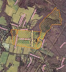
Aerial view of the "Hayden Farm" with the 4 separate parcels designated. Source: St. Mary's County Government.
File history
Click on a date/time to view the file as it appeared at that time.
| Date/Time | Thumbnail | Dimensions | User | Comment | |
|---|---|---|---|---|---|
| current | 03:50, 2 April 2009 | | 800 × 866 (348 KB) | Admin (talk | contribs) | Aerial view of the "Hayden Farm" with the 4 separate parcels designated. Source: St. Mary's County Government. |
- You cannot overwrite this file.
File usage
The following page uses this file: